The San Juan Islands are one of the great treasures for boaters in the Pacific Northwest, even more so for those who like to go hiking. Our previous column on the San Juan Islands covered our favorite hikes on Cypress and Sucia islands, and at Garrison Bay. In this installment, I’ll cover a few more excellent options.
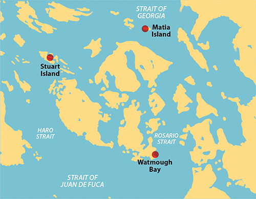
STUART ISLAND
Stuart Island is blessed with two large, protected bays on the north and south sides of the Island. Both have a state park dock, mooring buoys and linear mooring, plus plenty of room to anchor. Prevost Harbor is on the north side, but we tend to end up at Reid Harbor on the south side more often. It just seems easier to anchor and the sun sets earlier there, which is particularly nice on hot summer days. It also has a floating pump-out station, which is very convenient if you’ve been cruising the islands for more than a few days. The land between the two harbors is a state park with access to nice hikes.
First, there is the short walk between the docks in the two harbors, which we always take just to see the boats in the other harbor—there might be someone we recognize. There is a longer, circular hike in the state park lands between the harbors. But the best hike leaves the state park and walks up the gravel road from Reid Harbor to Turn Point at the western tip of the island. For most of the way the walk is well shaded by trees, but in the middle is a sunny stretch, the heat of which is eased by a cool, fresh drinking water stand that has been provided by the local residents.
Turn Point juts out into Haro Strait at the place where the shipping lanes make a dramatic turn. It’s an area of strong currents and orca pods are often sighted here, though in the many times we have been here we have yet to see them. It must be a matter of luck or maybe karma. Near the point is a side trail to the top of Lovers Leap Cliff where we’ve looked down on nesting peregrine falcons in the past. It’s kind of scary though—sheer drop and no railings.
There is a navigational light at Turn Point that is now automated, but the old keeper’s house has been turned into a museum. We always cap our stay with a visit to the unique outhouse with its Victorian decor. This is a very popular 5-mile hike that well deserves its acclaim.
MATIA ISLAND
Matia Island is a couple of miles east of Sucia Island, but is completely different in character. There is a cove on the southeast side where anchoring is possible but it is very exposed to southeast wind and waves. We’ve never tried it. The main cove on the west side faces Sucia Island and has a small state park dock that can hold two or three boats at most. There used to be two mooring buoys here, but they were gone the last time we visited; and we don’t recommend anchoring, as the bottom is poor and there is quite a bit of current. Whenever we are in the area we make a pass by the cove to see if there is room at the dock—once in a while there is, so we spend the night. We consider it a rare treat.
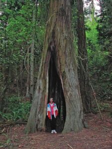
Matia Island, including its shoreline and offshore rocks is actually a National Wildlife Refuge, off limits to human visitors. But it also contains a Washington State Park that encompasses the dock and its uplands, together with a mile-long trail that circles the island. You can hike the trail but are not allowed off of it. And what a trail it is. We love it for its views of the water, its rocky outcroppings and for its stands of old growth trees, some of which have been hollowed out by fire but are still standing and growing. We always seem to be here on wet days when we can’t seem to avoid the island’s main hazard, its huge population of large black and green slugs. We wear our muck boots and are careful not to board the boat before cleaning them off since, despite our best efforts, the slugs are impossible to avoid on the trail. Someday we would like to hike Matia Island after a long dry summer—if there happens to be some of that hard-to-come-by space at the dock, of course.
LOPEZ ISLAND: WATMOUGH BAY
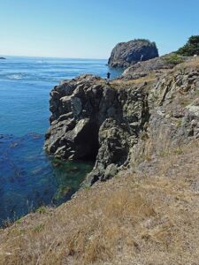
On the southeast coast of Lopez Island is a short, narrow inlet ending in a pebble beach called Watmough Bay. It is well protected from most weather, though we’ve been there while westerly gales were blowing in the Strait of Juan de Fuca and found it can be breezy but with no fetch. There are several free DNR buoys in the bay that we sometimes take, but usually we just anchor and have always had good results. The scenery is spectacular—on the south is a wooded hillside and on the north is a 300 foot high cliff that lines the entire bay. Over the years, we’ve seen nesting peregrine falcons and nesting turkey vultures directly from the boat. At the head of the bay, there is a gentle beach with wetland beyond and a broad path inland to Watmough Head Road.
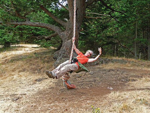
One favorite trail starts from the main access path just beyond the wetland or, alternatively, from a narrow path skirting the wetland on its north side. It then climbs steeply to the top of the cliff, the highest point (well back from the edge I should add) being 465 foot Chadwick Hill. It’s a rigorous climb but well worth the effort, and someone has even installed a rope swing at the top. If we explore closer to the cliff’s edge we can find a location that gives us a view looking down at our boat, at least if we anchored on the south side of the bay. Several loops are possible for the return trip and we enjoy exploring them, even though we have lost our way more than once and had to backtrack. The direct round trip to Chadwick Hill summit and viewpoints is less than half a mile.
We often add a completely different experience by hiking out the entrance path then east on Watmough Head Road to a side trail on the right after a quarter mile or so. The trail heads south to the Strait of Juan de Fuca where it continues along the top of the headlands within a narrow grassy strip between the cliffs and the forest with open views of the Strait and offshore islands. There are lots of options here. We think this is a perfect place for lunch on a sunny day. This loop is under 2 miles from the beach with little elevation gain.
These hikes and many others like them are just a few of the attractions that make the San Juan Islands a mecca for boaters in our area. Enjoy!
Michael and Karen have been cruising the Salish Sea and beyond for more than 20 years, hiking every chance they get. For more resources for hikers visit their web site at https://mvmischief.com/library/
For additional hiking information in this area Michael and Karen also recommend: Hiking the San Juan Islands by Ken Wilcox.