I’ve been flying quadcopters, more commonly now called drones, for over 10 years. Early on they were more of a fun hobby to build and fly, and less about quality pictures and video. In the last few years, that has completely changed, and you can now find drones in use on Hollywood movies and photography all over the place. I have taken lots of photos and videos with drones, but my favorites are bays and anchorages where you can enjoy the vistas and learn about the shoreline and depth contours.
Having grown up in South Puget Sound, I spent a lot of time at various anchorages and spots that are still fun to visit. One of my all-time favorites is Oro Bay, and I was there earlier this year with some friends and had the opportunity to fly the drone and explore via dinghy. Here’s an interesting look at Oro Bay from the sky, and how it matches up with features on a nautical chart.

Oro Bay is located on the southern tip of Anderson Island about 14 nautical miles south of Gig Harbor. A lot of charts call both the outer and inner bays by the same name, but there are actually two distinct bays: a less protected one to the east, and the inner one to the west — our chosen spot for several days last fall.
The challenge with Oro Bay is the entrance which, while not that difficult, can be intimidating if you’ve never been there before. The charts are also woefully lacking in detail both for the entrance and the bay itself. From the chart and when approaching the bay, you can see three important aids to navigation that mark the channel: red “2” and “4”, and green “3”.
Red “2” should be kept well to starboard when entering, and you should pass in between the green “3” and red “4” buoys. It’s also generally a good idea to avoid zero and especially minus tides for entering the bay, especially if you are a deep draft vessel.
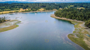
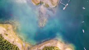
One of my favorite things to do with the drone is to get shots of water and land with the proper sunlight, light angle, and water clarity. This was especially useful in Oro Bay, given its somewhat tricky entrance. Getting a quality view from above provides a spectacular view of the shoreline, shallows, and contours underwater.
In the image of the Oro Bay entrance (page 23 – top right)you can see the first buoy at the bottom and then the two inner buoys near the center of the photo. What’s really cool is how clearly visible the shoals are beside both sets of buoys. If you have a drone, I highly recommend trying this when you anchor, but it takes some practice. And I suggest getting comfortable taking off and landing on land before flying it from your boat.
Flying from the boat
Flying a drone from a boat is a bit more challenging than from land for a few reasons. First, many drone vendors have “return to home” technology that relies on the GPS location from where the drone takes off. While at anchor, this will change the minute the drone has left the deck and your boat rotates in the wind or current. If you take off and your boat swings 10 or 15 feet, the home location will remain in that spot and your drone won’t know you’ve moved. You should make sure to either disable this feature, or use a feature some vendors have that uses the GPS location of your phone or the drone controller as the home point to return to.
Second, there are a lot of other automated technologies within drones that, while helpful to prevent accidents, can prevent you from having safe takeoffs and landings on a boat. These include things like automated landing/take offs, obstacle avoidance, and more. It’s important to be familiar with all the features your drone has, what situations they will be used in and, if possible, how to turn them off.
Automated landings can go terribly wrong when the drone is descending slowly and the boat rotates in the wind. Takeoffs are less of an issue since you can just jet up and away from whatever is rotating towards you, but still a bit more risky. Almost all drones allow you to takeoff and land manually, and it is a good thing to learn how to use these features. I always land my drones manually and have to abort landings at least 50% of the time because of obstacles, the boat moving, or other reasons. Again, the more you practice, the better you’ll get at landing in these situations. And my best advice is, don’t try to force a landing. If it’s not going well, back off, re-adust, and try again.
Obstacle avoidance is also something I’ve found very problematic, but not in all situations. Usually, I take off from the stern deck of Rendezvous, which is very open to the back of the boat. But there is an arch forward of the deck that drones get confused by as they rise up off the deck and start throwing all sorts of errors. It’s easy enough to back away, but it can be disconcerting if the boat is moving and the drone starts to do automated things that you didn’t anticipate.
On sailboats, it can be a lot more complicated to take off and land mainly due to the standing and running rigging, mast, and boom. Learning how to take off and land manually and
avoiding reliance on the obstacle avoidance feature is almost required to use a drone on a sailboat.
A controversial but sometimes necessary skill to learn when flying a drone from a sailboat is the hand launch and catch takeoff/landing. The safest way to do this is with two people — one person operating the drone, and one person as the catch and release specialist. It requires an experienced pilot, a lot of courage from the person catching the drone, and the understanding of how to catch and hold it so that it stops fighting them. Practicing on land is a good way to ensure you don’t end up with injuries.
Learning to fly a drone safely from a boat isn’t hard and the rewarding perspectives you’ll gain in places all over the Pacific Northwest are unique. Try it the next time you are in an anchorage like Oro Bay and you’ll be surprised to learn more about navigable channels, shorelines, and more. Plus, you’ll end up with some
pretty phenomenal images!
