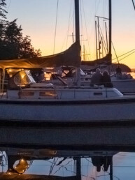
San Juan Island offers two distinctive beacons in two unique settings. Both reflect the ongoing story of mariners in the Salish Sea. When you are cruising in the area this summer, they are worth checking out by water and by land.
Cattle Point Lighthouse
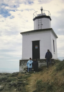
Photo by Lisa Mighetto.
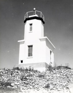
Photo courtesy of Washington State Archives.
It is hard to miss the Cattle Point Lighthouse when sailing through Cattle Pass and onward to San Juan Channel. This relatively short beacon, with its simple, clean lines and gleaming white facade, stands stark on the windswept bluff at the southeastern tip of San Juan Island. Sailors approaching or leaving Friday Harbor from the south can look for the light that flashes white every four seconds. While lacking in ornamentation, this beacon remains a dramatic, highly visible landmark in a specular seascape.
The Coast Salish have long revered this spot for its abundance of salmon, shellfish, and plants, including camas bulbs, that flourished on the prairie. During the 19th century, these and other resources lured settler colonists from a variety of nations, leading to questions about the rights of occupancy. In 1846, the Treaty of Oregon, signed in London, established the boundary between the U.S. and Britain at the 49th parallel, yet failed to clarify whether the border extended to Haro Strait on the west side of the San Juan Islands or Rosario Strait to the east. During the years of confusion that followed, both countries continued to occupy San Juan Island.
The Hudson’s Bay Company, an English enterprise, operated a sheep and cattle ranch on the southern tip of the island, where the animals grazed the prairie. In 1859 an American farmer who lived nearby shot an English pig that wandered into his potato patch. When British authorities threatened to arrest him, dispatching warships with guns aimed at the shoreline, the Americans formed a defensive camp at Cattle Point while English troops gathered on the northern part of the island. British Rear Admiral Robert Lambert Baynes attempted to de-escalate tensions, declaring that he would not “involve two great nations in a war over a squabble about a pig.” The dispute ended in the early 1870s, when an international commission ruled in favor of the U.S. and established the boundary at Haro Strait. Diplomacy thus prevailed in the “Pig War.”
Cattle Point remained an important strategic location, especially for mariners navigating the Strait of Juan de Fuca. During the 1880s, the son of a soldier formerly stationed at American Camp maintained a lantern on a wooden post, using kerosene that was dropped off at nearby Griffin Bay. According to the Seattle Daily Times, he carried the fuel in tin cans by horseback (March 6, 1960). In 1921 the Navy took over the light at Cattle Point, adding a radio compass station to broadcast signals for sailors making their way through dense fog. When the Navy closed the compass station in 1935, a modern concrete tower was erected.
During the mid-20th century, international yacht racers confirmed the need for a light at Cattle Point. In 1948, the International Cruiser Race — 145 miles from Tacoma to Vancouver, B.C. — proved to be “too tough” (Seattle Daily Times, July 19, 1948). “Yachtsmen were a tired, hollow-eyed lot when they checked in Saturday,” a reporter noted. “One yacht limped in, leaking from hitting a submerged log. The window of another’s house was missing, bashed in by Father Neptune.” The cause of this calamity? Many cruisers complained “they couldn’t find the weak-blinking Cattle Point Light because it was so rough in the Straits.”
Accordingly, the next year’s Capital-to-Capital predictive log race, which began at the Olympia Yacht Club, altered the course to run inside Deception Pass and scheduled the dates to take advantage of moonlight. The hope was that unlike the previous year, racers would not find themselves “aground here and there, milling around in the Strait of Juan de Fuca trying to find Cattle Point Light” (Seattle Daily Times, July 9, 1949).
In the late 1950s, the beacon was automated and its lantern was replaced with a drum lens that sits on top of the tower. The exposed optic uses photoelectric cells to activate the light at night. The Cattle Point Light was one of the first in the state to receive such an upgrade.
Lime Kiln Lighthouse
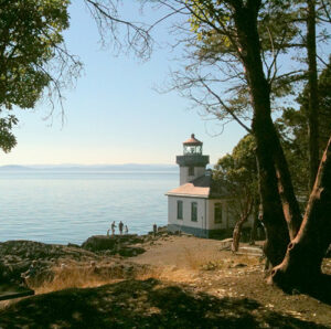
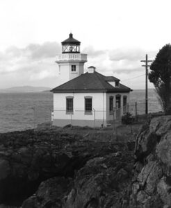
There are many reasons for boaters to explore the west side of San Juan Island. The scenery here is unsurpassed, offering views of distant islands and snowy peaks across the expanse of Haro Strait. Orcas, porpoises, seals, and other marine life are frequently spotted. Lush stands of Douglas fir, western hemlock, and Pacific madrone dot the shoreline. The Lime Kiln Lighthouse, which sits on the rocky shore overlooking Deadman Bay, adds charm and a glimpse into the past.
Named for the lime processing industry in the area, this beacon began operating in 1919. It was equipped with a fourth-order Fresnel lens installed in the 38-foot concrete and masonry tower and included an attached fog-signal building. The octagonal design was a replica of the beacon at Alki Point (see 48° North, May 2022), and like the Seattle light
station, featured two keepers’ residences behind the beacon. As this was a remote location in 1919, electricity was slow to arrive and early keepers had to do without. For several decades, an incandescent oil-vapor lamp was used as the light source in the lens, requiring constant vigilance by the keepers. In 1951, the light station converted to electricity, and the Fresnel lens was replaced with a non-rotating, 375 mm drum lens that used an electric light bulb. Electric foghorns were also installed at that time.
Louis Betteker exemplified the adventurous spirit of Lime Kiln keepers. In the late 19th century, the goldfields of the Klondike lured him west from his hometown of Canton, Ohio. “I started out to see the world and landed in Dawson at the time of the gold rush,” he explained. “Finding no gold, I came out and joined the Lighthouse Service.” (Seattle Daily Times, December 26, 1937). As a keeper at the Lime Kiln Lighthouse, Betteker distinguished himself in 1923 by rescuing two mariners whose boat caught fire.
During the 1930s, Betteker transferred to the West Point Light Station in Seattle, and Arvel Settlers arrived at Lime Kiln with his wife and five children. By all accounts, his kids sound like they were a handful. One day, for example, two of the boys decided to row all the way across Haro Strait to Canada, with their mother anxiously tracking their progress with binoculars from shore. When they returned, the boys concluded “It’s the same there as here.” On another occasion, the boys were on the water fishing when a whale chased their boat. “Oh, did we go,” one of them marveled. “We made the water fly.” A favorite activity was taking old boats that washed up on shore, plugging the holes with rags, and launching them using an oar as a rudder and gunny sacks as sails.
The Coast Guard automated the beacon in 1962, using photoelectric cells to activate the light at dusk. In 1998, the drum lens was replaced with a modern optic that flashed a white light once every 10 seconds. Today, the lighthouse is part of Lime Kiln State Park and is open to the public.
While the San Juan Island lights are remnants of the past, they are still operational. Both can be viewed when cruising San Juan Channel and Haro Strait, adding utility and beauty to this storied destination.
For more information on the Lime Kiln Light, see: https://www.parks.wa.gov/540/Lime-Kiln-Point
For more information on the Cattle Point Light, see: https://www.wta.org/go-hiking/hikes/cattle-point-lighthouse.
Lisa Mighetto is a historian and sailor residing in Seattle. She is grateful to Washington State Parks for information and materials for this article.
