The Canadian Gulf Islands are just across the border from the San Juans and are similar in many respects—in the large number of beautiful islands, the vast array of marine parks, and the wealth of opportunities for boaters, including hiking. In spite of the similarities, we find the hikes to be at least as varied as those in the San Juans. The cruising in the Gulf Islands is a lot like paradise, especially at this time of the year, and the quality and number of available hikes takes it to another level.

VANCOUVER ISLAND’S PORT OF SIDNEY
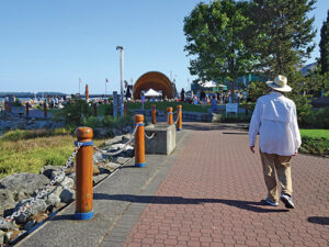
Often, we cross the border and clear Canadian customs at the Port of Sidney. We find this little community perfect for stocking our larder from the supermarket only a block away and, once chores are done, we take a nice long walk along its beautiful waterfront park, ending with a relaxing coffee break in town. Sometimes there’s even a concert in the band shell. It’s one of the best “city” walks we know.
SIDNEY SPIT MARINE PARK
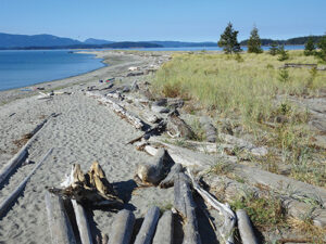
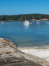
Across from the Port of Sidney is Sidney Spit Marine Park on the northern tip of Sidney Island. There is a dock for dinghies and smaller boats, and many mooring buoys set along the shoreline. We prefer to anchor, as there are modest depths over a good sand bottom. But the bottom isn’t flat; there are shallow areas that must be avoided, so we spend some time with the chartplotter and depth sounder to find the best place to drop the hook where you won’t run aground or hit another boat. And during prime boating season, especially on weekends, there are boats, lots of them. Perhaps half are just there for the day but their wakes seem to last until nightfall. So for maximum comfort, we like to visit on a weekday, early or late in the season.
We love to hike this park because of the variety of terrain encountered, partly in pine forest, partly in dunes and partly on sandy beaches. Hiking out to the navigation beacon on the end of the spit should be done only on lower tides since the middle of the spit is under water on high tides. It’s a 2-mile round trip from the dock. A longer hike goes through the pine forest campground and around the salt marsh to the dunes on the west side, perhaps 5 miles round trip. None of the hikes are particularly difficult but, because much of the time you are hiking in sand, they can be strenuous. We try to get back to the boat in plenty of time to relax and enjoy the spectacular sunset and twinkling lights of Sidney, provided we can manage to stay up that late.

TOD INLET

On the east side of Saanich Inlet, a bit over half way down is tiny Tod Inlet. This compact, totally landlocked inlet is best known as the boater’s gateway to Butchart Gardens, but there are other attractions as well. Anchoring is easy in the shallow inlet but it can be very crowded during high season. Luckily, short scope is not a problem in this super protected anchorage with a sticky mud bottom.
From the dinghy dock, a trail leads southeast along a creek until it comes to a road. Along the way, there are opportunities to cross the creek and hike the many trails of Gowlland Tod Provincial Park. For a different type of experience, walk east from the dinghy dock to the road and continue past Butchart Gardens on Benvenuto Avenue to a major intersection at West Saanich Road. There you’ll find the Victoria Butterfly Gardens where you will be able to roam a tropical setting filled with butterflies and tropical birds. It’s about 3 miles round trip of road walking, but well worth it for a unique experience. As an obvious alternative, a meandering stroll through Butchart Gardens never disappoints, either.
PORTLAND ISLAND MARINE PARK
Portland Island is a marine park with two fairly small anchorages each with a dinghy dock but no mooring buoys. Instead, they have a number of stern tie rings, a common feature in Gulf Islands marine parks that isn’t present in the San Juans. The stern tie ring is usually a large steel ring on the end of a length of chain that is securely fastened to a rock or cliff along the shoreline above the high tide line. It is used to tie the stern of your boat once you have dropped anchor. We find them a mixed blessing; they are very secure once established but setting one up takes time and some precision and can be especially difficult from our rowing dinghy when a wind is blowing. We have definitely seen some boaters do it in a way that appears to be routine but I can’t say we get enough practice to become truly proficient.
At Portland Island, we prefer intimate Royal Cove on the northwest side even though it is subject to wakes from passing ferries. After setting our anchor and establishing our stern tie, it’s time for a hike. The perimeter trail goes around the outside of the island, intersecting with spur trails along the way that either go into the island interior or out to a water’s edge. Once, when entering a grassy meadow we surprised a turkey vulture at a carcass; both of us were shocked. A stop by Princess Bay, the other anchorage on the southeast side, provides a view of the other boats at the island and, perhaps, an opportunity to meet other boaters. The perimeter trail is about 5 miles of up and down and isn’t difficult.
WALLACE ISLAND MARINE PARK
Wallace Island lies between the northern tip of Salt Spring Island and Galiano Island and is another marine park with stern tie rings. Conover Cove is small, with a dock for smaller boats and room for three or four boats to stern tie. The entrance is very shallow; we touched bottom there once when leaving the cove. Princess Cove is much larger with numerous stern rings. It is well protected from southerlies; we were stern tied here once when southerly winds reached 30 knots outside the cove and we were perfectly comfortable. We have anchored without a stern tie northwest of the cove entrance and been quite comfortable in normal summer weather, especially since the wind usually falls to light overnight.
Wallace is a long, narrow island with trails running its entire length and out every peninsula. The longest goes out to the northern tip of the island at Chivers Point where there is a camping area for kayakers. The point opens onto a narrow passage between islands with strong currents and a drying rock in the middle; we like waiting to see if any larger boats will attempt it. Some do, though we wouldn’t dare. The trail is about 5 miles round trip from the Princess Cove dinghy dock.
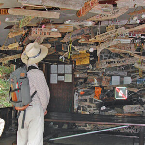
When we are here longer, or just feel more energetic we also head the other direction. Near Conover Cove there is an old cabin where boaters put up boards decorated with their boat name. The boards cover the walls inside and out. It’s fun to look for boats you know.
Another trail goes to the southern tip of the island at Panther Point, overlooking Trincomali Channel. Someone has kindly placed a small Buddhist shrine there to spread good karma to all Gulf Island boaters. With all the good hiking, Wallace Island is a welcome stop on almost every trip.
Michael and Karen have been cruising the Salish Sea and beyond for more than 20 years, hiking every chance they get. For more resources for hikers visit their website at https://mvmischief.com/library/
For additional hiking information in this area Michael and Karen also recommend: “Hiking the Gulf Islands of British Columbia” by Charles Kahn.
