This article originally appeared in the June 2021 issue of 48° North.
Many of us use boating as a way to disconnect from life on land or the daily grind, but when something serious happens, we want to ensure we have a way to call for help. The most universal way to do this on the water is through a VHF radio, but even then you might be faced with long distances or difficulties passing messages. If you’re ashore somewhere, it gets even harder to use a radio or cell phone out in the wilderness. This is where satellite communicators become very helpful.
 Satellite Choices
Just like smartphones or WiFi systems, there are a range of satellite devices you can use on a boat. At the top end you will find large dome devices from KVH or Intelian that will allow you to use your computer to browse web pages, make phone calls, and more. These domes require a lot of power, are very heavy and bulky, and cost a lot to install as well as operate. You can’t take them ashore or use them remotely if you are in an area with no cellular coverage.
Further down the range, you will find devices like the Iridium Go, which provide a very focused connection to download weather forecasts, simple emails, and make and receive phone calls. These are much cheaper than a big dome installation, but have limitations in terms of what you can do, and still have rather expensive monthly plans. They do have some features that are similar to satellite communicators, but are more geared towards phone calls and weather than simple communications.
Satellite communicators are at the lower end of the range, and provide a streamlined set of features around tracking, messaging, and rescue. They are usually quite small and are easier to use, many are ruggedized, are battery powered, and have very flexible monthly plans and service levels. Overall, these are mostly likely going to be the communications tool that makes the most sense for many Pacific Northwest mariners.
Satellite Communicator Functions
These devices are specifically designed for three major functions — tracking, messaging, and rescue. They can be used as standalone in most cases, or paired with a cell phone to provide a familiar interface. Some have screens and maps, while others are designed to work with a phone exclusively, saving cost and battery.
Tracking allows you to send a link or message to someone else so they can follow your progress as the communicator “checks in” every so often. This can be as frequent as 10 minutes, or as distant as just once per day. Tracking can be helpful when you are in places where there is little-to-no cell service and you want your shore-side followers to know you’re OK, to track where you are, and to ensure there isn’t an issue.
Messaging allows you to send simple texts using the device itself, or a cell phone connected via Bluetooth, to
people on shore. This can be great to let folks know you are OK, to coordinate meeting someone, or for non-life threatening emergencies.
Rescue is something we all hope we don’t have to use, but is a great feature built into these products. They all differ slightly, but generally speaking, they allow you to push a button and summon help from a call center that monitors for these types of signals. This center will reach out to the Coast Guard, fire departments, and other rescue agencies to try to coordinate reaching you. They can also use the messaging function to communicate with you and ask questions about injuries, locations, and more.
The two common choices for these devices are Garmin inReach and Spot Satellite Messenger. There are a number of other newer companies who have come into the market in the last few years and have some interesting offerings, including longer battery life and dedicated text message numbers, and are worth checking
out as well.
Spot was one of the first companies to offer these devices, and I had one in 2008 that I used extensively on the sailboat for years to help provide a more complete float plan or shoreside coverage on my longer trips. Garmin acquired DeLorme in 2016, another long running company with this technology, and have really given it a full facelift, while offering the technology in a bunch of different attractive packages.
Both of these vendors have a number of different options to choose from depending on how you want to use it. Garmin has better marine mapping and support than Spot, but both have the same base functionality for communications, apps for your smartphone, and other helpful features.
Subscription Flexibility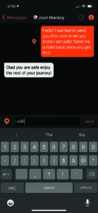
Many vendors in this space have realized that customers only use their devices for specific parts of the year, and have tailored their subscription plans to match. You can start/stop subscriptions at different times of the year with no penalties, downgrade and upgrade the coverage or options depending on your needs, and change many other aspects of your account.
They’ve also made the subscriptions reasonably affordable, with some as cheap as $12 per month. That’s pretty inexpensive to have such powerful features and communication options available aboard and ashore.
Aboard the Boat
Aboard the boat, I use my communicator every day when I’m underway. My shoreside contacts get a text message each morning showing a link they can use to follow my progress throughout the day. Of course, I also send them a text with my float plan and times if I am in cell phone range, but they can monitor my progress in real-time using the tracking feature.
During the day, if there are any issues where they can’t reach me via text or phone, they can send a message directly to the communicator which sets off a noisy alert. I can communicate with them via the messaging app on the device, and let them know if there is a problem.
More Features
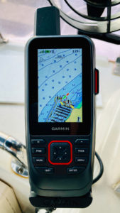
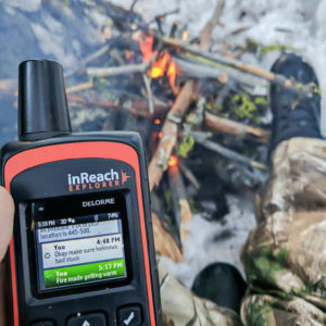
Several vendors are adding more features to communicators, with Garmin being the leader in this space. One that I use myself is the Garmin GPSMAP 86sci which is a satellite communicator plus handheld chartplotter. It’s built for marine use and includes their g3 charts, a floating and waterproof housing, plus connectivity to other Garmin devices.
For the outdoor adventurer, you can also add topographical and other land maps to the device, making it a perfect thing to grab when going ashore to explore. Not only do you have complete, detailed, offline maps and hiking information, but you can turn tracking on to ensure I know where I’ve been, and have a way to call for help regardless of cell phone coverage. Perfect for adventures terrestrial and afloat.
Vendors are adding other features as well, including things like marine weather forecasts, compass and other sensors, data from your boat network, autopilot control, and more. Many are devices with narrowed feature sets dedicated to certain types of activities like boating, backpacking, and off-roading.
 My Own Rescue
I firmly believe in communicators aboard the boat — and especially while exploring remote places on land — as a result of my own rescue situation. Having grown up on a farm and spent many years out in the wilderness and aboard boats in remote locations, I’m a fairly well-established outdoorsman. In February 2017, a friend and I went snowmobiling about 10 miles from the family cabin in eastern Washington with snow conditions that were pretty extreme. My snowmobile went over the edge of a cornice into a canyon, and became stuck in massively deep snowdrifts. My friend also got stuck, and after four hours of trying to get out, we knew we needed help.
It was very cold out, with highs only around 20 degrees fahrenheit — so we knew we had to create a shelter and take care of ourselves for the overnight temperatures. I was able to use my satellite communicator to talk to folks back at the cabin and arrange to have my brother try to reach us in the dark. He knew the area well and could bring equipment up on another snowmobile to help us get out.
He reached us a few hours later, and we were able to get everything out and back down to civilization. Without the communicator, we would have been on our own with a lot of worried friends and relatives. I have no doubt we could have made it out or survived the night safely, but if one of us was more seriously injured, it would have been far better to have the communicator to help coordinate rescue.
Having a communicator aboard your boat is a great way to provide a communication channel to people ashore. It allows you to let them follow your journey, and serves as a critical safety link to augment VHF or other methods aboard. It’s also essential if you are exploring shoreside in remote areas not only for maps and tracking, but also as a safety device to call for help if the unexpected occurs.