This article originally appeared in the May 2021 issue of 48° North.
Before the Wind by Jim Lynch, is a book about a Ballard-based family of boat builders and Olympic-class sailors. Youngest of the clan, Ruby Johannsen, had a sixth sense for the wind — how it would change over the racecourse and the course of the race. While her two brothers were also excellent sailors, she understood the wind just enough better to beat them around the marks on most days. Could this just be a sailing story about sibling rivalry, or did Ruby have true insight into the nature of the wind?
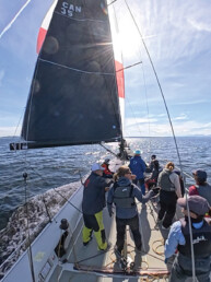
Gaining insight into the wind is important for more than just sailboat racing. All mariners want to have a reasonable estimate of the wind before leaving the dock and at all times while underway. Wind determines a sailor’s course and sail plan, and can affect a power cruiser’s travel and enjoyment. Wind creates waves that can limit boat speed and potentially affect safety. When docking and anchoring, wind is often the first thing that comes to mind when planning our approach. How we come to that constantly evolving estimate of the wind is partly by weather data collection, partly after a thoughtful gaze to the sky and water, and maybe even with a bit of
Ruby-like intuition.
The Synoptic Wind
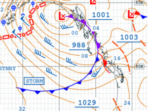
 The wind that Ruby and her brothers knew to expect heading out for a day on the water was the one predicted in the readily available National Weather Service Marine Zone Forecast. Wind driven by constantly developing pressure patterns is sometimes called the “synoptic wind”.
The synoptic wind will often be adjusted in the zone forecast to include the effects of large land features. The Puget Sound Convergence Zone in the lee of the Olympic Mountains is a well-known example.
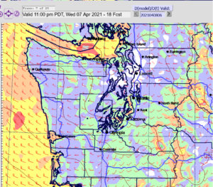
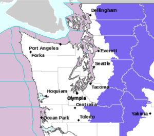
From one Marine Forecast Zone to the next, and even within a Zone, there can be large differences in wind speeds. In this color coded forecast from the University of Washington WRF-GFS weather model, the zone wind varies from 10 knots to 35 knots while under the influence of the same low pressure system! What can account for so much variation?
Coastal and Local Winds
 Frequently, it is useful to expect a coastal wind driven by the different thermal properties of land and water. Sea breezes, for example, build and veer through the course of a summer day. At nighttime, a land breeze will often cause a boat to swing dramatically on her anchor. The most predictable coastal breeze in this region is the thermal westerly that commonly builds in the Strait of Juan de Fuca in the summer. When the land east of the Cascade Mountains gets very hot, the hot air rises and the heavier cool air over the Strait is drawn like a vacuum to replace it, creating a westerly sea breeze.
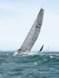
On one particularly blustery day, Ruby beat her brothers by sailing full speed, dangerously overpowered, past the leeward mark, then jibing in a nearshore wind shadow, narrowly avoiding a violent grounding. Ruby knew the wind in the Zone forecast could be affected by even very small scale land features. And she somehow knew how to anticipate and benefit from that localized, terrain-induced lull in the wind.
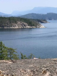
The complexity of a typical shoreline causes coastal winds to be too localized for description in the Zone forecast. But scale is a relative thing. A small variation in wind to the weather forecaster can be a big deal for the skipper of a suddenly overpowered boat off a lee shore! So, it is left to the mariner to “read” the shoreline for its various effects, large and small, and make her own adjustments to the Zone forecasted wind.
Clouds and Wind
 After one frustrating loss, Ruby’s brother Bernard asks, ”Why are you always looking up? There are no telltales up there. What are you watching?” Quite possibly, Ruby was studying the clouds.
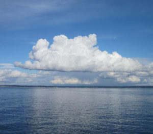
Air circulation in a cumulus cloud creates a surface wind pattern that moves with the cloud as it drifts along in the upper air currents. The life cycle of a cumulus cloud produces two nearly opposite wind patterns. As a cumulus cloud forms and grows, air is pulled inward from below, forming an updraft into the cloud.
In the second half of the cloud’s life, if it grows to the point of producing rain, a downdraft forms. Updrafts and downdrafts modify the wind nearby. Updrafts tend to increase wind speed aft of the cloud and cause a lull ahead. Downdrafts cause the stronger surface winds forward of the cloud with a lull on the aft side.
Winds Aloft
Even on a clear day, without the telltale signs of wind from clouds, air from aloft can find its way to the surface. Ripples or “cat’s paws” to windward are a good sign that a change in the wind is on the way. Cumulus clouds and cat’s paws tell us the air is unstable and turbulent. As air from aloft tumbles to the surface, it brings along the upper air velocity; likely higher in speed and often veered in direction. The intrusion of wind from aloft appears to the sailor as a gust, demanding a response in trim, helm, or both.
The Zone forecast will give us the strength of gusts when they are expected, but it is left to the mariner to know whether the gust will veer or back. Keeping a “weather eye” is maybe the best way to anticipate when and where the gust will happen.
 Apparent Wind
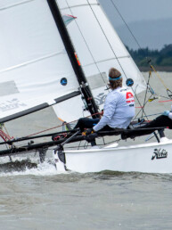
While not an actual source of wind, the apparent wind must have been another part of Ruby’s sixth sense. Once a boat starts moving, the apparent wind direction moves towards the bow and wind speed increases. All of the Johanssen family agreed that a faster boat makes more wind and more wind makes a faster boat. But, the true wind must be kept in mind as weather systems evolve, clouds develop, and shorelines change.
Putting It All Together
Few of us have the gift of divining the wind like Ruby Johanssen. Or, as she told her brothers “…maybe the wind just loves me more than you.” For the rest of us, a more systematic approach is needed.
Try keeping a mental checklist of the multiple sources of wind: synoptic, coastal, cloud circulation, gusts from aloft, and apparent; and pair that with local observations and land effects. Estimate their combined effects over your course and time on the water. The synoptic wind as modified by the Zone forecast is a great place to start. Then add or subtract wind speed and veer or back wind direction with your estimate of each of the other winds to make your own unique forecast. Even without Ruby’s sixth sense of the wind, a deeper understanding of forecast and its influences will help us sail faster, be safer, and ultimately have more fun on the water.