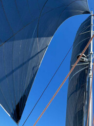
No one told me there would be spiders. When I moved my boat from saltwater to Lake Washington a few months ago, I expected to make adjustments, but the spiders were a surprise. So many have made themselves at home in my cockpit that my husband Frank and I have named the friendlier (or bolder) stowaways. When it’s time for a sail we ask each other, “How about it? Want to take the spiders cruising this weekend?” I calmly flick away the gossamers as my friends chat to us in the cockpit, cheerfully unaware of what is dangling above their heads. In more than 20 years of sailing the South Sound, I had noticed only a few of these hitchhikers, all hiding in the anchor locker.
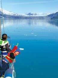
Boating on the Lake Washington system is different from saltwater in many ways. When anchoring around Olympia, I could feel the tidal shifts in the hull. Changes in water color often signaled a river or stream ahead. Currents collided around islands, sometimes creating foaming torrents and whirlpools that I call “swirlies.” Logs and lines of floating leaves—green in spring and gold in fall—hinted at tidelines along heavily forested shorelines. Lake Washington waterways have their own rhythms, revealed to cruisers who look closely.
Boating here is mostly an urban experience, made possible by extensive engineering projects in the early twentieth century. After completion of the Lake Washington Ship Canal in 1916, Lake Union became “the watery heart” of Seattle, according to guidebook authors Jo Bailey and Carl Nyberg, who found it “busy, noisy, and endlessly fascinating, day or night” (Gunkholing in South Puget Sound). Though written in 1997, these words remain true today. Lake Union offers mariners one of the best views of the city, featuring gleaming skyscrapers and the iconic Space Needle, along with colorful houseboats (so far, a bright purple one in Portage Bay is my favorite), a variety of restaurants with docks, multiple marinas and yacht clubs, and countless industrial sites, including boatworks—all concentrated in a relatively small area.

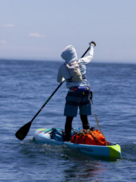
Evening and weekend cruisers are sure to have plenty of company, surrounded by sailboat races, floating hot tubs, tour vessels, standup paddleboards, canoes, kayaks, and all manner of power boats, many of which are continually engaged in a dodging dance with seaplanes. After the quiet beauty of the South Sound, it is sensory overload. “This is crazy,” Frank commented on our first cruise here, dazed as we zigzagged through a gauntlet of watercraft.
We prefer the southern end of Lake Washington, with its slower pace and storied shoreline. Yet the most striking thing about this area is what is no longer here. For centuries, a complex network of rivers and streams converged at the southern end, creating a waterscape lined with trees and marshy vegetation, thriving with salmon. The Black River was a central feature, described in numerous historical accounts as a “vein,” “artery,” and “heart” of Lake Washington and the lifeblood of Seattle, as it once formed the only outlet to saltwater. In keeping with this anatomical metaphor, I think of the Black River as a lost limb, one that is now gone but occasionally makes its presence felt. The tale of its fate is one of the most compelling in our region’s history.
An Enchanted River

Mariners turning south from the ship canal will find a bucolic shoreline, passing stately residences with large manicured lawns and lavish flower gardens. Several parks, including the Arboretum, Luther Burbank, and Seward, offer lush, green spaces. Gene Coulon Park at the southern end of the lake includes docks and a boat launch, providing a pastoral break from the industrial setting of the Boeing Plant and the paved runways of the Renton Municipal Airport. For thousands of years Lake Washington—once called “Lake Duwamish”—flowed south into the Black River at this point.
Named for its dark, organic-rich water, the Black meandered south until it joined the Cedar River flowing from the east. The combined waters moved west, where they joined the White River, which flowed from the glaciers of Mt. Rainier into the Duwamish River. This serpentine river system twisted its way northward, eventually emptying into Elliott Bay and providing the only link from Lake Washington to saltwater. High tide slowed the flow of the Black and, during periods of flooding, the river backed into the lake, creating the strange spectacle of water moving in opposite directions. In Chinook jargon, the Black was called Mox La Push, “the river of two mouths.”
The Duwamish People lived along the banks of the Black River for thousands of years. Using weirs, they fished the bend in the river where the water turned westward, creating a deep pool “loaded” with salmon in the summer. Native canoes traveled this ancient route northward up the Duwamish River, to reach the clams and oysters in the tidelands of Puget Sound. The forested hills, dark with tangled vegetation, inspired stories of supernatural beings and events.

During the nineteenth century, non-Indigenous settlers quickly recognized the potential of the Black River. Before the arrival of rail lines and roads, the region’s waterways carried coal, lumber, and farm products from Southern Lake Washington to Seattle, with steamers traveling the Black and Duwamish during periods of high water.
It did not take long for the Black to attract tourists and recreational boaters, who flocked to the resorts appearing on its banks. Pacific Sportsman, a regional outdoor journal, advertised the mouth of the river as an excellent fishing ground for kokanee (landlocked sockeye). “At spawning time they crowd each other in thousands,” one article promised in June of 1905, providing “good sport for the bait fisherman.”
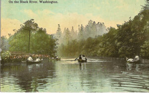
The following year, the Seattle Post-Intelligencer featured the Black River as an idyllic place for a canoe trip. “You enter … from Lake Washington at the southern end of that body,” the author reported. ”The waters of the river are deep and slow and placid, flowing silently over a black and boggy bottom out of a bay grown thick with slender reeds, and upon whose glossy surface water lilies rest their broad green pads” (Sept. 9, 1906). Photos and drawings of canoes carrying women in long white dresses and fanciful hats underscored this poetic account. These ladies languidly trailed their fingers in the water as they floated past dogwood blossoms and wild currant, while Douglas-firs, cedars, maples, and cottonwoods covered the hills lining the river. Examining the illustrations closely, I half-expected to see woodland fairies and water sprites in the background. Who wouldn’t want to canoe through such a dreamy setting?

A River Lost

For all its charm, the Black River posed a problem for deep-draft boats. Shoals, sandbars, and snags obstructed the route, while tidal fluctuations and meanders in the waterway slowed the progress of commercial vessels. During the 1890s a 46-foot steamer ironically named Success foundered on a trip down the Black. It took a team of horses and the aid of Indigenous canoeists to pull the boat over sandbars covered by less than 3 feet of water. The passage down the Black could be “a hell of a job,” recalled one steamboat captain. “Getting a line on a stump or tree was not an easy way to make a living especially when you are wet up to your neck” (“Black River Passage,” The Sea Chest, June 1, 1974).
These navigational hazards were particularly inconvenient given that the Black River was the only link between Lake Washington and Puget Sound. As early as the 1850s, Seattle’s boosters advocated constructing a canal to connect Lake Washington to the Sound through Lake Union, so-named because it would one day join these two bodies of water. When Washington became a state in 1889, one of the first acts of the legislature was to petition Congress for a feasibility study for the canal. The US Army Corps of Engineers, charged with improving navigation on the nation’s waterways, conducted the survey, pronouncing the Black “a very tortuous stream.” The rivers in the Lake Washington system had always been winding, unruly, and unpredictable, flowing in all directions and frequently flooding and changing course. While the Duwamish People adapted to these conditions, many of the new, non-Indigenous residents sought control and efficiency, at least in the short-term.

By the early twentieth century, city leaders had mustered the political will and funding to reshape the river system with a series of massive projects. Work on the Lake Washington Ship Canal began from 1909-1911, culminating with the opening of the locks in 1917, which allowed the orderly flow of marine vessels through the channel from salt to freshwater. Lake Washington now discharged through the ship canal rather than through the Black River. As the level of Lake Washington lowered nearly 9 feet, water drained away from the Black.
“The waters just went down, down,” recalled Joseph Moses, one of the last Duwamish to live along the river, “until our landing and canoes stood dry and there was no Black River at all.” The receding water left salmon trapped in isolated pools in the riverbed. Moses remembered people coming “from miles around, laughing and hollering and stuffing fish into gunny sacks.” Without fish or water, Indigenous residents were forced to leave their homes, while the recreation business on the Black eventually disappeared (David M. Buerge, “Requiem for a River,” Seattle Weekly, Oct. 1985).

As engineers blasted the canal and the Montlake Cut, related projects in the early twentieth century similarly reshaped Seattle’s shoreline. The Denny Regrade moved mountains of soil from Denny Hill to the tidelands around the Duwamish River, allowing this waterway to be filled and straightened. Meanwhile, rivers in the southern end of Lake Washington were redirected. The White River, which once joined the Green before flowing into the Black and Duwamish, flooded in 1906. A large log and debris jam moved the White southward, and construction of a permanent diversion wall ensured that the river would continue to flow in this new direction. In 1912, the City of Renton diverted the Cedar River, which had flooded the previous year, so that it bypassed the Black and emptied into Lake Washington. Within a few decades, the natural waterways of the Lake Washington system had become barely recognizable.
Today, the ship canal is mostly used for recreation – and the volume of traffic on a summer afternoon indicates that many boaters continue to benefit from early twentieth-century engineering. Who can say if my sailboat would now be moored on Lake Washington had this massive reshaping not occurred a century ago? And yet, as I sail in front of Gene Coulon Park on a lake transformed, it’s hard not to mourn the losses, including the displacement of Duwamish People, destruction of prime salmon habitat, and disruption of what was once a boating and fishing paradise.
Remnants of the Black River still appear in the form of scattered reeds along the shore, while echoes of the old lake persist during periods of flooding. Modern boaters are connected to past Lake Washington voyagers in our love of being on the water and the joy of paddling, rowing, sailing, and motoring through such a scenic setting. I am still learning to recognize traces of earlier eras as I explore this freshwater system. Meanwhile, I am adjusting well to boating with spiders.

Lisa Mighetto is a historian residing in Seattle. Her interest in the Black River dates from 2005, when her article “The Strange Fate of the Black River” was published in Journal of the West. She is grateful to the Renton History Museum for photographs and assistance in her research.