Here’s part three detailing the Niemann’s voyage across the COVID-closed world to reach their home waters of the PNW.
Read Part One, Turkey to Singapore and Part Two, Singapore to Japan.
Ginger wasn’t sure what to expect about cruising Japan. During our time aboard Irene in quarantine in Singapore, we had read and heard stories of difficulties cruising there. When she corresponded with various Japanese bureaucracies, she despaired at the complexity of the requirements. It seemed like every email revealed new hurdles.
As she worked at the computer, Ginger suddenly burst out laughing, “Listen to our arrival instructions from Naha Coast Guard.”
“What’s up?” she read. “Now look, you’re gonna wanna tie up to the pier just before the bridge.” In contrast to the very formal, almost stilted language she had come to expect, a Japan Coast Guard officer had written perfect American slang. Our laugh foreshadowed more delightful surprises we enjoyed during our three-month cruise up the Japanese island chain.
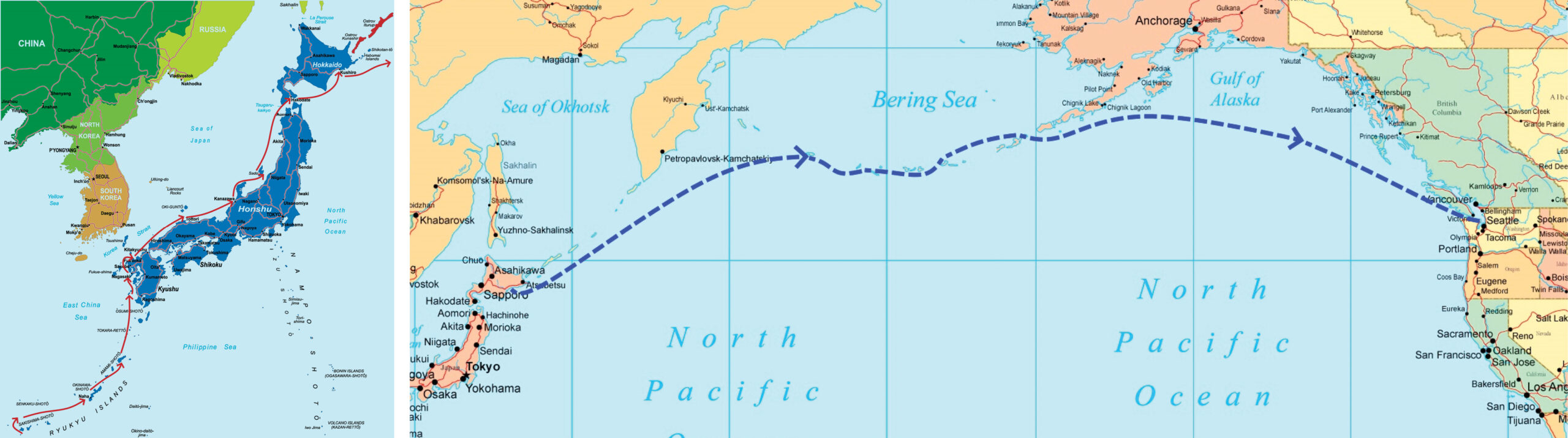
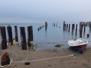
Weeks later, after we arrived in Naha and had a chance to observe the local scene, we understood better — with a big U.S. military presence in Okinawa, it’s easy to see why informal American English is spoken and understood. We paused there long enough to quarantine and put a new coat of bottom paint on Irene before we started island-hopping.
To keep our mileage average high enough to stay on schedule (only a bit more than two months to cover 1,600 miles of coastline from south to north) we sailed short passages of up to four days when the wind blew strong in the correct direction for us. In between, during periods of light or adverse wind, we took very short hops or explored on land.
Cruising Fact vs. Fiction
There were many rumors about cruising in Japan, but what would we find? First, we discovered the food to be amazingly tasty and high quality. A person could eat quite well by shopping only at convenience marts, similar to the revered 7-Eleven. Try that in the USA! We had been led to expect the people to be earnest, friendly, and helpful, and this turned out to be completely true. We had also expected the sailing to be difficult and dangerous, based on prevailing wisdom. This turned out to be untrue, at least for us along our route up the west coast.
Rumor: Currents, seaweed, fog, heavy shipping and fishing boat traffic make coastwise sailing dangerous.
Truth: Skippers with vessels equipped with radar and AIS and the skills to use them will have no difficulty. Fog, seaweed and traffic are very similar to those same challenges in many parts of the Pacific coast of North America.
Rumor: Cruisers are not allowed to explore at will, and are restricted to only a few industrial ports in expensive marinas.
Truth: Changes over the last few years have opened up the possibilities. A cruiser can visit many small fishing ports now, and there are hundreds of them. Most of the small fishing ports we visited were free of charge and adjacent to charming small villages.
Rumor: Provisioning is difficult, with exotic food and unreadable packaging. And no one can help you because English is not widely spoken.
Truth: Just point a smartphone at characters that need translating. Like magic, English words appear. And if a young person is nearby, it is very likely that they speak enough English to be able to help. Japan seems to be well-served by food stores of all types. It was rarely more than a very short walk for us to find what we needed, and provisioning had never been easier or more interesting.
Rumor: Japan is best visited by air rather than by sailing.
Truth: Japan gave us some of the most interesting and unusual cruising we’ve ever encountered, and the sailing itself was actually very good.
Farewell Japan
We arrived on schedule at Kushiro, our last port in Japan before heading offshore to the Aleutian Islands of Alaska. Warm clear water, tradewind breezes, and vacation culture in the southern Okinawan islands had reminded us of Hawaii in some ways. At Kushiro, in contrast, on the northern island of Hokkaido, we were reminded of Alaska. On the waterfront, a chill wind blew off a cold gray ocean. Kushiro is a working town, and offshore fishing industry infrastructure was prominent. Dusty streets and peeling paint on buildings suggested hard and cold winters.
Shivering in the cold and wind, our bodies were still acclimatized to tropical heat. But we didn’t mind because it was exciting to realize that we were finally about to head into the North Pacific on the next leg of our journey home. And Irene’s cabin was wonderfully warm because our reliable Reflex diesel drip heater was pumping out dry and even heat.
With our stomachs full after dinner we drowsed happily, and heard a knock on the hull and a shout. It was Seki-san, the agent who would help us clear out of Japan, fresh from Tokyo. He had jumped on the train as soon as he heard we were in Kushiro. We invited him down below and Ginger prepared snacks and warm drinks, and we heard stories of sailing in the area. He had sailed both to Russia and Dutch Harbor several times, and we listened carefully to his suggestions. He warned us to avoid an area where large drift nets were routinely set, and suggested that we stay well offshore of the Kuril Islands.
With Seki-san’s help the exit procedures went smoothly, and we were free to sail. After a last check of tide and weather, we were ready to go. Seki-san untied our dock lines and we set off down river, with Seki-san waving from the quay. As we cleared the river mouth and started hoisting sail, Ginger gave a shout and pointed. It was Seki-san, just a dot on the breakwater at the river mouth and still waving. She called out, “We’re gonna miss Japan!”
Onward to Alaska
We left in a good strong wind, setting only mizzen and jib and making good progress in the 6- to 7-knot range — Irene’s sweet spot. Over the years, we’ve learned to always leave a body of land in a good wind if possible. It’s disheartening to slowly and painfully sail away, or even worse, motor away from land. After all, on a passage, the departure is the only time you can reliably choose your weather.
During the voyage, the mizzen was cycled from full to first reef to second reef and back to full mizzen many times. As was the jib, from full to two or three rolls on the furler and to almost completely furled. Eastbound lows swept by us every few days, so as the wind shifted, our point of sail varied from close reach to broad reach. But the mainsail was never needed. And more remarkably, we never had to heave to. The wind and sea never increased to such an intensity. But the seas were rough and we were damp and cold. Condensation ran down the bulkheads in rivulets. Cushions and bedding were constantly damp. We couldn’t even read off-watch, as our glasses fogged up instantly.
the westernmost part of the USA.
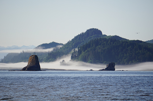
Irene arrived in Attu, the westernmost part of the USA, nine days and 1,350 nautical miles later, still sailing under mizzen and jib. Our spirits soared as we approached in a thick fog. Dodging and weaving per radar and plotter, Irene sailed past islets that we never saw. We hardened up close-hauled, then tacked to point directly at Navy Cove — at least, so the chart plotter promised.
Then, miraculously, we could first see the outlines of land, and as we dropped anchor the fog lifted a few hundred feet to show the whole lower part of the bay. It was stunningly beautiful, with lush green hills partially obscured by wispy clouds and spotlighted by patches of brilliant sunlight. The scene was so calm and quiet after the noisy week on the open ocean. Blissfully free from keeping watches, we slept soundly that night while the heater drove all the moisture out of the cabin.
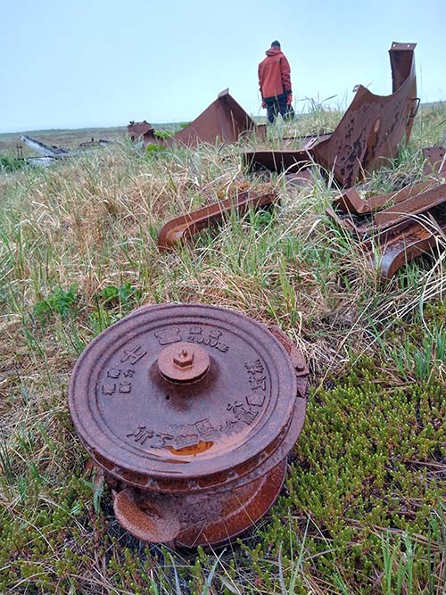
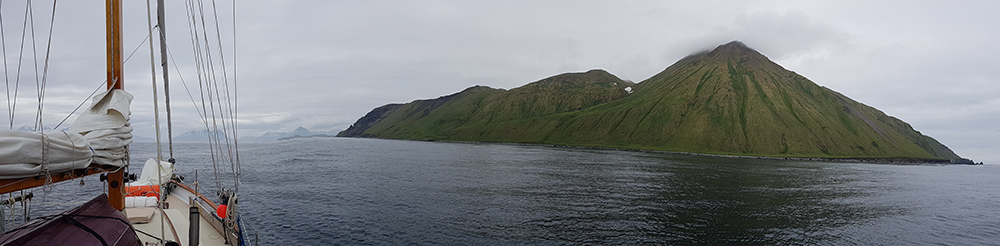
Although Attu is currently uninhabited, it shows lots of evidence of past military activity. There are ruins of buildings and piers, rusting equipment, and roads with signs warning of unexploded ordnance. But no people, just thousands of birds. We rowed ashore daily and walked for miles and miles. After a few days of island exploration, we were ready to start sailing northeast, island-hopping up the Aleutian chain towards Dutch Harbor on Unalaska. An overnight hop brought us to Kiska, where we anchored in 35 feet of water over beautiful black sand.

Kiska is also deserted. It shows even more evidence of wartime — the Allies bombed the heck out of it in WWII. We could see scars and eroded bomb craters in the hills behind the beach in front of our anchorage. We launched the dinghy and rowed ashore. It was fascinating to poke through the wartime debris – aircraft engines jumbled together with heavy equipment, kitchen utensils, boat parts. One part was marked in Japanese, another next to it in English.
Another hop brought us to Adak, an inhabited island at last, and where it was rumored that fuel might be available. But the place seemed completely deserted, and Ginger got no answer from her calls on VHF radio. We tied up to a wall in a small boat harbor. We had just decided to go for a walk when a small pickup truck drove up, and we met our first American since arriving in the U.S. over a week ago. The friendly driver said a fuel truck was on the way. “No one would stop here if they didn’t want diesel!” he said.
As we were filling the tank, we learned that his Aleut grandmother had lived on Attu and been evacuated as the island was militarized in WWII. The human costs of war can persist for generations.
Sailing here is complicated. The Aleutians are on the border between two big bodies of water, the North Pacific and the Bering Sea, each of which produce wave trains of different types that collide in the islands. The tides are big, causing strong currents, and gales or near-gales are frequent but with short duration. Also, there is fog. A lot of fog. The wind is chopped up and funneled between the islands; therefore it makes sense to avoid traveling directly in the chain. Instead, it’s better to plan hops either in the Pacific or in the Bering Sea.
The wind seemed to be usually stronger than ideal or painfully light, and we had read that some sailors preferred to motor in calms and wait out the periods of high wind at anchor. But distances are large and fuel requirements can be significant, and passing time in anchorages is more pleasant during calm periods. Accordingly, we adopted the opposite tactic by sailing in high wind and anchoring and exploring in calms as much as possible.
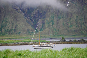
Given this strategy, it wasn’t surprising that we approached the busy Dutch Harbor in a gale. Irene was driving hard under just a tiny bit of sail set, with spray flying high as we passed the containership port. We wondered if we would be able to make the final turns into the tight international dock under power, considering the windage on our rig. Ginger hailed the harbormaster without response, but received a call back from a familiar name. The Austrian sailing vessel Muktuk, which we had last seen in Nome four years ago, was tied up at the international dock and let us know that the basin was protected enough from this wind to maneuver.
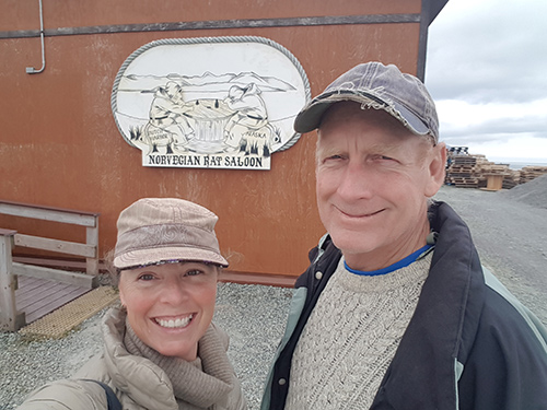
Our time in Dutch passed in a blur — catching up with friends, clearing customs, internet, fixing broken stuff, purchasing a replacement kerosene lamp, inoculations, hiking, refueling and reprovisioning. We celebrated completing an eastbound circumnavigation (as we had just crossed our outbound track) at the Norwegian Rat Saloon. It turned out that Captain Karl of Muktuk is wonderfully skilled at engine repair and sorted our failed front seal and a stuck circulation pump. Mate Ali has encyclopedic knowledge of local flora and fauna, not to mention her gourmet cooking. After seeing almost no one for weeks, we were in a social whirl. It was wonderful and we partied until we began to feel exhausted. We needed to put to sea again just to get some rest.
Home at Last
Irene has previously traveled between Dutch Harbor and Neah Bay on two different paths, and we had a choice: a long trip of day hops and overnights up the Alaskan peninsula and across to Southeast Alaska then down the Inside Passage, or a simple direct open sea crossing of the Gulf of Alaska. Considering that the Inside Passage of British Columbia was closed, it was easy to choose the direct route. Thus, we departed in a good wind, as we prefer, and pointed Irene’s bow directly at Neah Bay.
We sailed quickly into the fog and did not emerge until a week later. The wind began to ease as the sun began to shine. The cover of the mainsail came off for the first time on this passage and we hoisted it in sight of the glorious mountains of Vancouver Island. A day and a half later we dropped the hook in Neah Bay just after sunset. As we’d experienced before along this COVID-19 journey from Turkey to Port Townsend, we were not allowed ashore because of the pandemic. Sigh.
The next day Irene had a rollicking run down the Strait of Juan de Fuca and anchored at Port Townsend. Here we were allowed ashore, and Ginger announced, “We’re gonna wanna drink a beer!” So we rowed ashore to the beach in front of the Pourhouse. We were truly home and that beer tasted just fine!
Originally from Seattle, Peter and Ginger Niemann now call Port Townsend home after two circumnavigations. They were awarded the Cruising Club of America’s Blue Water Medal in 2022.