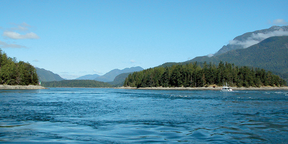
For boaters looking for adventure beyond Desolation Sound, some of the best cruising on the British Columbia coast lies farther north through the passes that lead to Johnstone Strait and to the Broughton Archipelago.
There are three possible routes to make your way north, two of which have excellent anchorages. The east route, with few anchorages, transits the dreaded Dent Rapids but has easy access from Desolation Sound. The “middle” route takes in Surge Narrows and the Upper and Lower Rapids of Okisollo Channel. The “west” or main channel encompasses Discovery Passage and Seymour Narrows—although it can be a little intimidating, it is the main direct route for commercial traffic and is the one we usually take when heading north.
EAST ROUTE
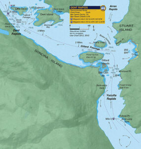 Boaters departing Desolation Sound can take the passes that include Yuculta Rapids, Gillard Pass, and Dent Rapids. This four-mile stretch of strong current takes a bit of planning, but the bottom line, if northbound, is to arrive at Yuculta Rapids just as the current turns to ebb.
Traveling northbound, the Yucultas will be the first challenge. The predominant characteristic of these rapids is the choppy water and turbulence that starts south of Kellsey Point and continues to Gillard Passage. Although this passage is deep and fairly wide, the middle of the pass has the least turbulence right up to Whirlpool Point.
If arriving at the tail end of a flood, you can take advantage of an eddy along the Stuart Island shore up to Kellsey Point. From there, if conditions are safe, cross over to the Sonora Island side of the channel (where the northerly ebb current kicks in early) and continue to Gillard Passage.
Be aware that large whirlpools and holes form east of Gillard Island during flood conditions. The area southeast of this island is especially dangerous during large flood tides, as is the area between Jimmy Judd and Gillard Islands. The flood set towards Jimmy Judd is very pronounced at the west end of the island.
Heading north to the Dents, boaters will see on a chart that the main problem with Dent Rapids occurs during the flood—a result of the tremendous wrenching Little Dent Island gives the tidal stream. This forces a major deflection of current over to the Sonora Island shore. In a large tide, the deflection has the appearance of the edge of a waterfall as it actually drops onto the eddy east of the QR light.
On the ebb, the stream at Dent Rapids is much more consistent because there is nothing to deflect the stream. If you find yourself riding a faster ebb than planned, stay in the middle of the pass, as there is a set to Tugboat Passage and the rocks therein. If southbound, try to arrive at the Dents as it is turning to flood and favor the Sonora Island shore.
MIDDLE ROUTE
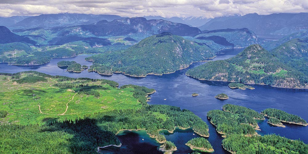
 Surge Narrows and Okisollo Channel are a good option for boaters departing from Rebecca Spit or Desolation Sound. This is a scenic route running between Quadra and Maurelle islands and has the attraction of the beautiful Octopus Islands, located in the middle of the passes. This route is also good if you plan to continue on to Johnstone Strait, eight miles northwest of the Lower Rapids in Okisollo Channel. This middle route is probably the easiest of the three northern routes and offers the added bonus of superb scenery and excellent anchorages. The first rapids are Surge Narrows and, six miles north, are the more turbulent Upper and Lower Rapids in Okisollo Channel.
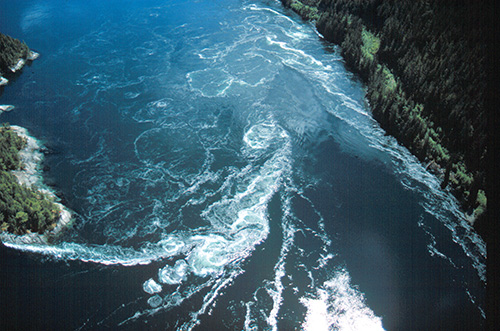
Surge Narrows and Beazley Passage is the fastest-flowing pass of the middle route and currents here can be turbulent, especially on the south-setting flood that can reach 12 knots. On large tides you must arrive at Beazley Passage very close to slack, within 15 minutes, to ensure a safe transit because this pass turns very quick on large tides. Fortunately there are no twists or turns such as those at Gillard Passage and the pass is easy to navigate. Connecting Hoskyn Channel with Okisollo Channel, Surge Narrows actually begins at Welsford Island at the southeast end and extends northwest through Beazley Passage, where the current is strongest, and then to Surge Narrows between Antonio Point and Quadra Island.
Beazley Passage is the only safe channel through the Settlers Group of islands. On the flood, there is significant deflection of current off a point southwest of Sturt Island jutting to Peck Island. This generates tremendous turbulence and appears as a shear zone of current crossing the pass. Working the eddy off Sturt Island and crossing this shear is not an option during strong current as it is easy to lose control and, because the pass is narrow, there is little room to recover. If you are going with the southbound flood be sure to give Tusko Rock a wide berth and favor a course closer to Peck Island.
The ebb produces less turbulence, but there is a set towards Tusko Rock, which dries at low water and is located just west of Sturt Island. Boaters should favor the west side of the passage until clear of Peck Island.
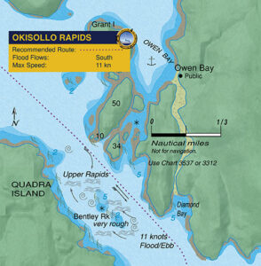
Currents in Okisollo’s Upper Rapids, the first set of rapids encountered when northbound, are considerably stronger (up to 11 knots) than those in the Lower Rapids, which usually run less than 6 knots. The Upper Rapids passage is also encumbered with reefs and rock outcroppings that generate strong deflection. Seas can be quite turbulent in the area near Bentley Rock during large tides.
The safest route through this pass is a course favouring Sonora Island giving Bentley Rock a wide berth. On the south-flowing flood, the strongest deflection is just south of two small islets (one of which is marked ‘10’ on Chart 3537) on the east side of the channel below Owen Bay. The north-flowing ebb in the Upper Rapids is even more confused, especially in the area downstream (north) of Bentley Rock. Be careful to avoid the strong set to Bentley Rock by crossing to the east side of the channel well upstream. Currents in Okisollo are strongest around this rock and the forces of water here are very hazardous.
Although Okisollo’s Upper Rapids can be turbulent, the pass is wide and there are opportunities to pull out and assess the situation if conditions are uncomfortable. Owen Bay is a good anchorage to wait out strong ebb tides. The Lower Rapids are more benign, with currents rarely exceeding 5 knots in the channel south of Gypsy Shoal. The channel north of Okis Islands is free of hazards with less current. Okisollo Channel enters Discovery Passage about 4 miles south of Chatham Point, which marks the eastern entrance to Johnstone Strait.
WEST ROUTE
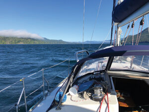
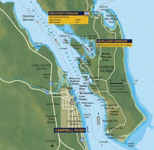 About two miles in length and less than a half mile in width, this is our favorite pass to get to Johnstone Strait. Located about eight miles north of Campbell River, it takes a bit of planning to arrive at Seymour Narrows at the right time and often gives first-timers the morning jitters because of its reputation. Although there are several good marinas in Campbell River, there is also a good anchorage nearby in Gowlland Harbour, which is well protected from most winds and has very good holding.
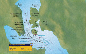
Hydrographers say the strongest currents at the narrows are in the vicinity of Ripple Rock (slightly west of mid-channel, directly beneath the hydro lines between Vancouver and Maud islands). On a flood, the strongest turbulence will be along the west wall and the area south of Ripple Rock. On an ebb, the turbulence starts between Maud Island and Ripple Rock. The top of this rock was removed in 1958, leaving a minimum depth of 45 feet.
Northbound vessels should arrive off the Maud Island light within a half-hour of a strong ebb finishing or beginning (neap currents of less than 8 knots give latitude of up to an hour). Arriving near the start of the ebb is perhaps best as it makes for an easier passage northbound. Once into the narrows, keep on the dark water or “tongue” of the current to avoid the whirlpools and eddies north of Maud Island up to North Bluff. The main thing is to try to stay clear of white water and turbulence. If you have a small sailboat with low power it might be prudent on big tides to be at the Maud Island light at slack or just a few minutes into the north-flowing ebb.
One aspect of Seymour Narrows, and a common characteristic of most passes, is the increase of wind speed in the narrowest part of the pass. This is especially vexing if a strong northwesterly is blowing down Johnstone Strait and the wind tries, like the current, to squeeze between Vancouver and Quadra islands. It’s not uncommon to experience winds of over 30 knots in Seymour Narrows in summer months.
If you’re northbound and the slack is at low water, be sure to arrive at the pass before the end of the ebb because slack on large tides doesn’t last long—5 to 10 minutes at most—and you’ll want to be past Brown Bay before the south-flowing flood gets underway, which can be brutal in a slow-moving boat. On a large flood, currents in Seymour Narrows can reach 16 knots—no place to be in any kind of boat.
Southbound boats should be opposite Brown Bay within the hour of a flood ending or beginning. If a large spring flood is underway, it would be wise to be here within a half hour of its end or beginning. On floods, the Sailing Directions advise to keep well away from the west shore when transiting the narrows. Once past Ripple Rock there is plenty of room to maneuver away from any northbound vessels. The good news about Seymour Narrows is that there are no obstructions and just one strong, main stream.
 For northbound boats the tension eases once you’re past North Bluff, and upon reaching Separation Head the currents lessen considerably. The only hazard that might remain will be the strong northwesterlies that are common in the summer months. Discovery Passage leads north to Kanish Bay where there are several good anchorages.
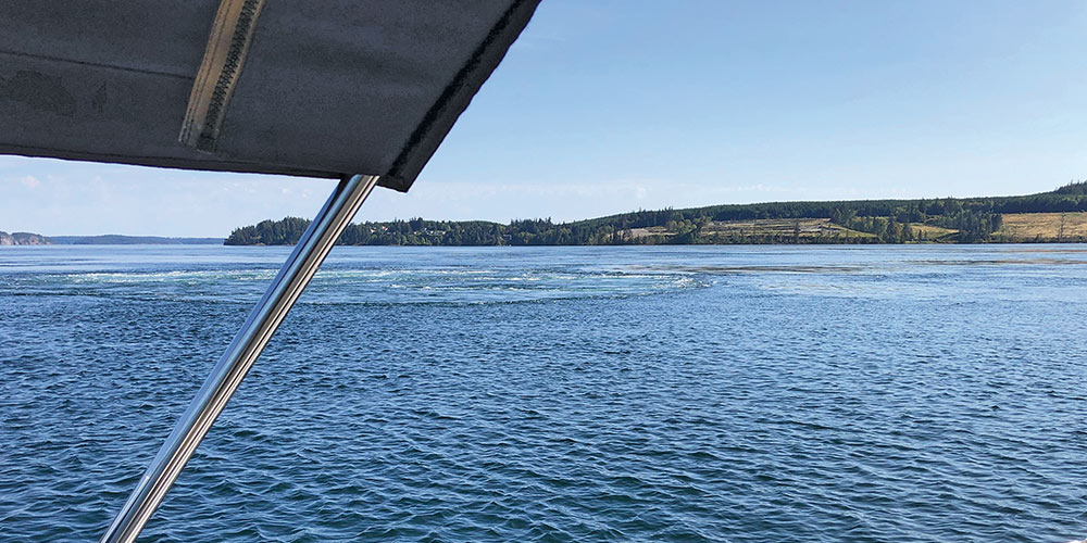
For the northbound boater, Discovery Passage starts south of Cape Mudge, where the first effects of south flowing flood currents are felt a few miles north of Mitlenatch Island. Even during calm conditions, the waters here can be a little choppy and rolling. During strong southerly winds (25 knots or more) against a flood stream, the seas can be dangerous. In the past, numerous vessels have been lost in this area, usually during winter storms. In summer, southeasterlies are not as common, but seas can still be rough and currents strong in the area a few miles south of Wilby Shoals.
Discovery Channel, between Campbell River and Quadra Island, is a busy place so, in addition to the current, be prepared for traffic. There are the hourly crossings of the Quadra Island car ferry, the comings and goings of tugs and barges, fishing boats, and numerous pleasure craft. From May to October, cruise ships on the Vancouver-Alaska run regularly use this pass, most heavily on weekends, usually transiting during evening or night-time slack. The captains of these ships have great respect for Seymour Narrows, for their flat-bottomed ships tend to slide stern-out in sharp turns, like the blind corner in this pass. On weekends in the summer, there can be four or five cruise ships lined up from Cape Mudge to Seymour Narrows.
Despite the sometimes busy commercial traffic, Discovery Passage is fairly wide and straight and it is easy to pick a clear spot if you need to cross over to Campbell River. Keep your VHF on Channel 16 if you need to clarify a situation with another vessel.
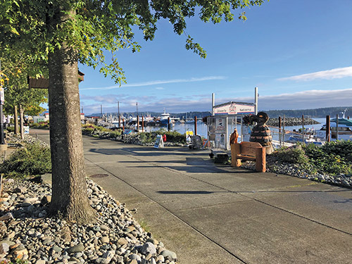
Although we have transited Discovery Passage many times over the years, there is still something exciting about this route once past Seymour Narrows. Hemmed in by the steep slopes of Vancouver Island and the forested shores of Quadra Island, this wide ribbon of cold, swift-flowing water bustles with commercial traffic all summer long. If you are taking this route, Campbell River with several marinas, makes a good stop to reprovision, fuel up or enjoy a restaurant meal.
All the information in this story and much more is included the book, Best Anchorages of the Inside Passage. Award-winning authors William Kelly and Anne Vipond have written about cruising the B.C. Inside Passage for over 40 years, their stories appearing in yachting publications across North America. Best Anchorages of the Inside Passage, has been recognized by the Society of American Travel Writers as an outstanding work in travel journalism and receiving a Lowell Thomas Award in the guidebook category. The new revised second edition of this book covers anchorages from the Gulf Islands to Bella Bella and includes Desolation Sound and Broughton Archipelago. The book also covers pilotage for all the tidal passes leading to Cape Caution and all the best anchorages along the way. Their book is available at bookstores and leading chandleries.