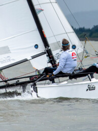
Making the most of a pandemic holiday, I did what sailors do — I sailed. I left Boat Haven late Friday morning bound for Scow Bay, at the southern end of Kilisut Harbor. A Gale Warning had been declared for the evening, with southerlies continuing on and off through the weekend. As I set out, the sustained wind was only Force 4 to 5, but the gusts were exceptionally stronger. For these reasons, I hanked on the 80-percent jib. Sampaguita, my Flicka 20, was a bit under canvased in the sustained winds with this headsail, but could really dig in, with no need to luff, during the gusts. Taking and shaking reefs in the mainsail as the wind vacillated, we beat across the bay to the entrance of Kilisut Harbor.
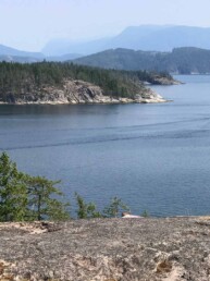
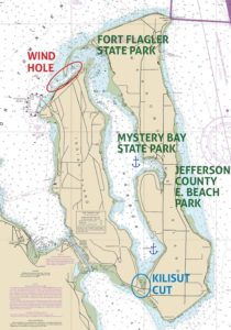
Kilisut Harbor is a four-mile-long inlet between Indian and Marrowstone Islands on the east side of Port Townsend Bay. Its narrow and shallow hook-shaped northern entrance is directly across the bay from Port Townsend. Day sails around my home bay are fun, but the scenery changes little, and the anchorages are generally exposed. If I only have a couple days to cruise, Kilisut is the closest destination where I feel I have actually gone somewhere. Mats Mats Bay and Port Ludlow are other potential destinations, but currents and longer journeys are considerations with increased challenges when sailing in limited winter daylight.
 A trip into Kilisut Harbor offers anchorages within 10 miles of Port Townsend and with manageable currents most anytime. The challenge is depths. Have a chart at hand. While a small craft may feel comfortable sailing the channel, vessels with deeper draft may want to motor and follow the markers closely. There are two state parks with mooring buoys, docks, or both. Additionally, a decent summertime anchorage lies off of Mystery Bay, and Scow Bay makes a good wintertime anchorage.
The just-hiding-around-the-corner vibe of Kilisut gives me a feeling of seclusion. The only general store on Marrowstone Island recently burned down, so there are presently no services. This was a sad development for many. Indian Island, to the west, is a U.S. Naval armaments depot and is off-limits. Since anchoring and unplugging have been my main objectives, I have managed these limitations okay.
As I approached the entrance to Kilisut on that winter weekend, Sampaguita sailed into a wind hole. This was expected. With the high bluff of Indian Island to the south and east, the wind consistently becomes light and variable here, regardless of its strength or direction out in the bay. Likewise, the current is variable and seems to be influenced by water flow over the spit between Rat Island and Marrowstone Island, a few hundred yards up the channel. I eked my way through the dead spot under sail and oscillated between wishing I had the genoa up and knowing it would be tedious to tack in this light wind, hanging up on the shrouds as I chased the wisps of wind back and forth. No, the 80-percent jib and patience would see me through, and the sustained wind and gusts were only a stone’s throw away.
I caught up with the wind just after the red number six day marker, and headed north on a starboard tack, reaching up the narrow channel lined with submerged sand and mudbanks. Following its 180-degree hook to the right, I trimmed the sails tighter and tighter until I was forced to short tack in front of Fort Flagler State Park.
This state park at the northernmost end of Marrowstone Island has a few mooring buoys in the channel, and during the summer, a dock. I have stayed at both before. When at this dock, I recall a south wind kicking up, bringing waves slapping uncomfortably against the hull. It is most sheltered here in the summer months, with the predominant wind from the north. When winter winds shift to the south, the dock would be on an exposed lee shore, so it is removed. Fort Flagler, one of three early 20th century forts that guarded Admiralty Inlet, has battery ruins to explore and some great views to the north. Rat Island, on the port side as you enter the harbor, was originally an extension of the Marrowstone Island spit. Now cut off by a channel, it can be reached by dinghy. It is a bird nesting area, and sometimes herds of seals are sunbathing.
Once past the red number 12 day marker, I fell off onto port tack and held this course until the green number 15. From here, the rest of the way to Scow Bay was a back-and-forth beat upwind. I did a sail-by of Mystery Bay along the way to see what the conditions were like at the state park dock in case I needed a fallback.
 Mystery Bay, half-way down the harbor, indents Marrowstone Island and has a like-named state park. Its permanent dock and mooring buoys provide for transients in a bay otherwise quite crowded with private buoys. Much of it is a Voluntary No Anchoring Zone to protect shellfish beds, but, west of the park and just outside, anchoring is easy in settled weather. While Mystery Bay seems a central hub of Marrowstone, with the general store gone and a state park whose main feature is the waterfront, there may not be much reason to leave the boat. One activity is a walk across the island to Jefferson County East Beach Park on the Admiralty Inlet side. An aural quirk, Mystery Bay is within earshot of the Indian Island broadcast system, with the National Anthem and bugle calls sounding daily.
The wind was picking up as I passed Mystery Bay, and I put a second reef in the main while clawing my way down the harbor. I could see four boats moored ahead in Scow Bay, suggesting local knowledge concurred with my anchoring plan. As I made my final approach and sussed the anchorage, I chose a spot just south of the others and was already pleased with how much protection from the southeast wind there was. I headed up, dropped the headsail, let the sheet fly on the main, and sank the anchor. I was in about 25 feet of water and figured the bottom to be muddy. With plenty of room to put out as much scope as suited me, I started with 160 feet. Now midafternoon, I settled in and made myself comfortable. I ended up staying here for two nights.
The protection from south and southeast winds was excellent in Scow Bay. During the Gale Warning, only the strongest gusts got through. I increased my scope to 220 because I could. Halyards slapped and the anchor rode groaned, but there was no fetch, so it was comfortable. However, if a northerly were to blow, the anchorage is exposed to the whole fetch of the harbor, and I would search elsewhere. The road that skirts the bluff on Marrowstone offered a considerable amount of noisy, daytime traffic. However, the evenings were more still, and I could hear the casual conversation of what I think were servicemen on Indian Island patrol. Scow Bay would be a convenient place to anchor a mothership overnight if planning a human-powered exploration of the new channel connecting Kilisut Harbor to Oak Bay.
By mid-morning on Sunday, the south wind filled in and I sailed off the anchor for my return trip to Boat Haven. Another of the anchored boats was headed to Port Townsend for water, and we traveled up the harbor together at 5 knots — they, under power; me, under sail. I switched between wing-and-wing and a broad reach, depending on the topographically affected wind. They began to pull away as the channel narrowed, and my course became less optimal. Then I hit the wind hole. So much for sail versus diesel. C’est la vie. I carried on sailing as I do and meandered back across the bay to Port Townsend in a fading wind, another pandemic holiday in the bag.
Kilisut Harbor is likely old news for more long-standing locals. As a new arrival to the Port Townsend area, it provided some nearby exploration and peace. When based in Seattle, I made a couple stops, but mostly passed it by for more ambitious destinations. Now, with the limitations of a pandemic, I took advantage of its close proximity to study it in more detail, keep me on the water, and as a sanctuary. Kilisut Harbor is now on my list of great Puget Sound nooks and crannies.